
Foothills Below Yosemite
Posted on March 1st, 2014 in Uncategorized | No Comments »
Feb 20-24 2014

Trails during a drought year.
2013 was a very dry year in California. Although autumn didn�t produce the normal light rain activity that commonly hits between September and November, we did have an unusually cold December with higher than average precipitation that dumped snow at very low levels.

It looked like the winter season would be a wet one, but it didn�t turn out that way. After Christmas, the month of January 2014 turned out to be one of the driest on record and the December 2013 snows just didn�t pack enough of a punch to make a huge difference. Not that drought is a surprise in our area; we usually get a few years of extremely dry conditions about every 10 years or so. There are those rare years that the upper elevations of Yosemite are practically void of any snow during early winter and the National Park Service keeps the Tioga Pass highway open. If you ever get the chance to visit Tenaya Lake or Tuolumne Meadows during December or January you need to jump at the opportunity. Even though the pass stayed close this year as usual, January was the warmest I�ve ever seen and all but the highest altitudes were void of snow. It set the tone for early winter travel� hit the trails before the rain and snow returns and closes them.
I did a couple of runs above the community of Coulterville by myself during mid January and it was unusual to see fire restrictions in effect after the December storms. Generally you don�t need a fire permit until March but I thought it would be a good idea to grab one. Everybody has been on pins and needles since the Rim Fire took its toll last fall. The forest fire was huge and it destroyed several places I camp at.

During my December visit I wasn�t too happy seeing the destruction caused by the fire.

It�s going to be interesting this summer when everybody will be packed into what areas are still accessible.
I had been in touch with my buddy Steve over the holidays and he made it clear that he wanted to do some kind of trip before March. Being it was so dry up here we tried to work in some dates during February to do a 4×4 run around Yosemite. In late January and early February we finally had a few storms move through and the dry spell was broken. I worried that the forest service would close what trails were open but the ground really sucked up the water and it did help finally turn the hills green. So the trip was set and it looked like the weather was going to cooperate. I got in contact with my buddy Don to see if he was willing to come along and he was up to it. Every year we get together for a late winter rendezvous and it looked like this would be our annual 2014 trip.
This was a short trip� only 4 days. The plan was to set up a base camp and take a couple of trails close to the site. The campsite would be around Anderson Flat close to the Old Coulterville Trail. It�s a spot I�ve camped at since the 1970�s.
The Trip:
Most of this area was new to Steve except the Briceberg road. I E-mailed him directions on how to get to base camp after confirming the date. State route 132 is the main road into the area and passes through Coulterville. The Anderson Flat area can be found by clicking on the link below as well as the other spots we visited.
Anderson Flat (Map link)
Dogtown Road (Map link)
Schilling Road (Map link)
Texas Hill.
Burma Grade also called Briceberg Road.
Fuel and supplies:
There are several places to fuel up in the general area but one of the better stores is located in Greeley Hill. It is a fairly large market and has fuel including diesel.
Off to the hills:
Don drove up to my place and we left out late Thursday bound for camp but our first stop was a restaurant called the The Lumberyard.


This place is a local hangout around Lake Don Pedro and is located in the foothills between the towns of La Grange and Coulterville. It�s a bar that has live bands from time to time but they also put out some good BBQ food whenever they�re open. The food is plain old homemade stuff. Linguicia and Tri-Tip sandwiches, burritos, and quesadillas, are great but their burgers are huge.
After chowing down a fantastic grilled chicken breast club style sandwich (that actually resembled their huge burger) along with an order of onion rings�oh yeah and a quart draft to wash the sandwich down, we were finally off to camp.

The sun was setting fast. We had an hour drive but Steve didn�t leave out of LA until noon and was hoping to make camp by 10PM. Thankfully nobody else was in camp. There just isn�t a whole lot of room where we wanted to set up at due to how small the camp is. On top of heading into a small camp I noticed on my last trip up there that the Forest Service blocked off a major section of the campground. That didn�t make me happy at all. If the forest service keeps going the way it is now it won�t be long before there will be virtually no dispersed camping available for the public. After setting up, we finally got a fire going. I left a marker light at the road to point Steve in our direction.

Steve pulled in exactly on time. It was good to see him again and after he set up his van we finished out the night sitting around the campfire. This time I brought my trailer full of wood.

Time to break out the adult beverages and enjoy the night.


It was a long drive for Steve. The fact was we were all tired. It didn�t take much to knock any of us out for the night but Steve fell quickly into the abyss yet he NEVER dropped his cigar.
Friday:
In the morning we didn�t get up until about 8AM. The morning was brisk but not too cold.


After the espresso ritual and a light breakfast, we left out for our first run to just grab some firewood.

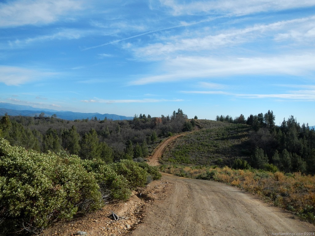
The best spot for wood was fairly close to camp off a spur road I have never been on before but Don had been there often. Although short, it is a cool little run and provided the weather is clear, the views can be spectacular. We had semi-clear views on this outing.


The previous rains from earlier had left some mud holes.

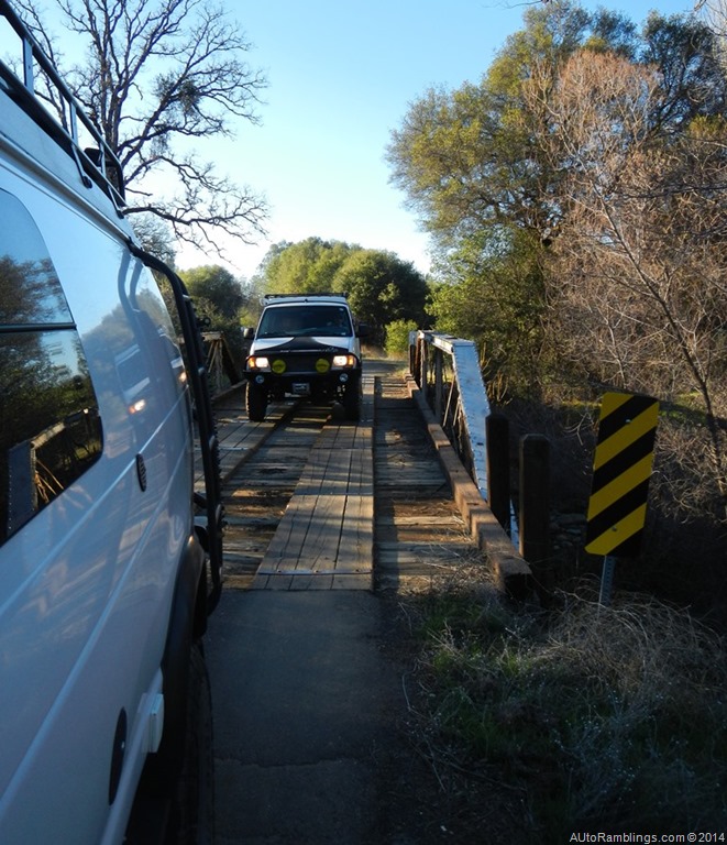
After grabbing up our bounty of wood, we returned to camp to unload, grab a brew and set out on our trip to Schelling and Dogtown road. Much of the drive to our destination backtracked along the road into camp, so some of it was paved. Don rode with Steve during most of the runs. The first part of the trip would take us over a fork of the Merced River, a crossing that can be difficult to ford during wet weather. We knew this year there wouldn�t be any issues so we headed out.


Moore Creek bridge below.

Moore Creek road (a spur off this road) once offered several places to camp at along the creek. No Longer! The forest service has closed off most of the spots over the last couple of years and have not relocated or opened any other camping spots. People had camped here since the beginning of the 20th century. The spots were fairly clean considering how well used they were and it bothers me that the camps were closed down.
Soon we turned left on to Dogtown Road which can be seen on the left in the picture below. The road splits off and climbs quickly.

Dogtown can be considered an extension of the Old Coulterville road and is a direct route to the town of Coulterville.

The road is not maintained during winter and can be slick in spots during and after rain.

Another feature of Dogtown as mentioned earlier is crossing a few creeks including a fork of the Merced River.

There are times that I can�t get across this section in my van when the water is high. But the drought curbed the wild waters to a trickle during this visit. Below is the second crossing that isn�t near as deep during high water.


The road becomes a paved route that winds its way through a residential zone. This section has several cabins and ranches, some of which are very nice.

A Valentine left over from a few days back.


After crossing through a backcountry residential area, the road splits where Dog Town and Schilling rendezvous at. Not far down the road the pavement finally ends.

Schilling Road is a foothill route that drops in elevation to CA Highway 49, an old 49er trail of the past 1800�s. I wrote about this route a few years back in my post the Old Coulterville Trail and clicking on the link will provide more information.

More of a trail, Schelling Rd travels through open cattle range country and is usually passable except during wet weather when the road is slick. Because it is cattle country, a series of gates are usually closed.

It�s important to keep the gates closed for obvious reason while traveling the route. Permissible access through open range cattle country is becoming more and more limited as roads like these are being closed to the public.

It�s important to understand you�re driving through private property so stay on the main road even if you see a side trail.

Veering off the road is trespassing and is handled as such. It�s common to see a bull from time to time but although generally passive just be aware what an angry bull can do, so avoid them when possible.
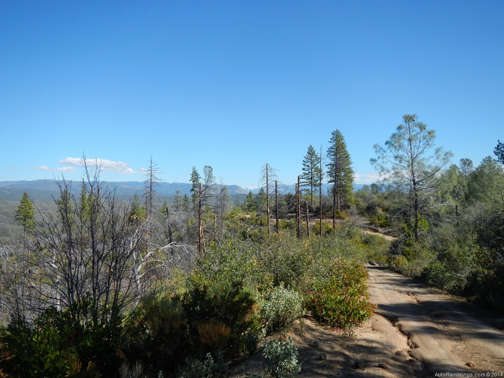
Much of the run follows a ridge before dropping in altitude.


You can get the feel of the old west driving through the region which can be a treat for those who have had limited experiences traveling in this type terrain.


Because of the drought this year, grasses were slow to grow and grazing was limited for ranch owners so almost all of the gates were open on our adventure due to the lack of cattle.


Although this is a county road, a picture of my van on this road was featured in the summer 2013 Expedition Portal Overland Journal Sportsmobile ad proving it�s a very scenic springtime run that appears to be a remote area. Because of the gates it actually is. Most people turn around when approaching a closed gate.


In some spots you can grab a glimpse of Half Dome along the route, but the scenic greenery of the lower foothills is often unmatched with or without Half Dome in the background.

(A close up of Half Dome)

We pulled over at a nice spot close to a big oak tree.

After taking a few pictures I noticed the rear driver tire was low. Later I was to find that the rim was defective. Thankfully I had an on-board air compressor.
The views are classic foothill vistas of the California gold rush areas. It�s hard to believe that thousands of people occupied these hills during the 1849 gold rush.


Towards the end of the road you pass through a ranch.


After passing through the ranch, it�s backcountry until highway 49.


A couple of trail thugs told me not to mess with the locals or I might not ever be heard from again. Heeding their words I stuck to the trail. Who would screw from such serious faces like these?
After hitting Highway 49 we zipped into Coulterville.
Steve had passed through town on the way up but it was dark so we made a pit stop.

In the past the bar did put out some great food but rather than pay bar prices for food and drink we decided to head back to camp. It was a very tough decision to pass up the bar.

There were plenty of people about and I always get a chuckle from the looks when 2 or more Sportsmobile�s come into a small town. Seems we always get looks like the Government is in town especially when the vans are the same color.

We saw a suspicious tourist hanging around town and decided to avoid the guy. Don said he looked like the kind of guy that might come out of LA.

Coulterville has a bit to offer as a gold rush town.

On the way out of town I took Steve by some of the older buildings in the area.


Things go better with Coke?


That LA dude seemed to be following us.
This building is one of the oldest in town and a historical spot many stop to see.

The sign says it all.
After our short visit we were off to complete the section of Dogtown that we had passed up to take Schilling. Some of this route can be very scenic during a good springtime flower bloom but we were a little early for that. No big deal, it was still a nice Sunday drive even though it wasn�t Sunday.

Part of the road follows along and crosses Maxwell Creek which runs through Coulterville. The town of Coulterville was actually called Maxwell�s Creek in its early history.


The sun was setting so the trip was thrown into high gear.

I did have time to take a picture of one homestead sites along the route. Again for more info on this road you can read my post on this site, �The Old Coulterville Trail???.
After completing Dogtown we headed to the store at Greeley Hill for some ice and then back to camp. Another night around the campfire was great as usual but it did tell us we needed to restock the wood supply the next day. My mom�s famous meatloaf slider burgers with English Muffins hit the spot for dinner along with a variety of standard finger foods. As usual Don supplied high quality cigars and coupling a few Rocky Patel�s with some good whiskey and Vodka, times were good. There was a lot a classic music and laughter. This night led well into the next morning� can we say hangover generator!
Saturday:
Ok the morning was a bit rough but there was no reason to get up too early. This would be our layover day. Espresso did its job and it was a mellow day.
Don had shown us where to find an abundant supply of wood and I brought along a few weapons to do some target shooting. There are a few good spots around Texas Hill to do some trap shooting and what not.
After picking up some wood, Steve got to try out his brand new Sven saw. I�ve had one of these things since the early 70�s and still carry it today. Other than a chainsaw, I think it�s one of the best items to keep aboard.

The sun was setting around the Texas Hill area by the time we wrapped up our wood cutting session.
The fire was going to be unstoppable this night.

Again the drinks flowed as the music echoed up the canyon, and our laughter was so loud it was lucky nobody was close by.

We fired up the BBQ to tamed our growling stomachs.

Same as our last adventure less than a year ago, we were the three amigos once again. Sometimes things just click. Don brought some killer finger food that cooked up well in the BBQ and Steve had some Asian ribs that hit the spot. We actually had too much grub with us once again.
The day was rough� wood chopping took the best out of us so the evening came earlier than normal� well for one of us at least.

Still we were all tired. This was our last night and we all made a break for the sack earlier than the night before.
Sunday:
Morning came, the coffee was brewed and we prepared to head home.

We had enough wood to sit around a morning fire before leaving out. We also cooked up a few goodies that we had left over from the night before.

No these are not gray chicken wings, rather stuffed spinach wraps that tasted way better than they looked.


A little hair of the dog? No way� it almost made me sick thinking of it.
We had enough time to take one last trail. We set out toward the Texas Hill Trail.
(Click on smaller images to enlarge)


The trail is were we had gathered wood the day before and starts where a section of private land occupies a large meadow area. The Trail was wet in sections but we knew from the previous days we were in there that the mud holes had a good solid bottom. We didn�t need to lock the hubs. In the lower right picture above as well as the lower left, you can see why we gathered wood here�it was everywhere.


Some of the mud holes weren�t exactly shallow.


Steve and Don kept in touch via radio and lagged back due to the dust I left behind me.

Texas Hill is in the picture above and below.


Much of this area is thick in low level shrub brush.


Fire had ran through this region several times over the past years destroying most of the tall trees. Sometimes fire can make things better but it also can ruin the scenery.


A small creek runs through this area and can pose a problem in wet weather.


These ruts may not look deep but they were. Heavy rains can make this simple trail more complex.

Yosemite Valley in the background.

Outstanding views of Half Dome.
This was the crest of the trail and in general it was all down hill from here.


The forest began to thicken where fires had left less of an impact.


It�s difficult to see in this sun blinding image but a tree had fell across the trail. This is common after a storm has passed through. No big deal unless you have a trailer and need to backup.

Finally the trail crosses the Burma Grade trail. From here we turned right heading toward Briceburg.

Steve, turn right Steve!
The Burma Grade Road, also know as Briceburg Road, is a trail I�ve taken and written about so many times that I wonder why I�m even posting about it here.

Well, here it is but I�m not posting much about the run.


The trail winds its way along a gradually down sloping grade that runs along an impressive mountain shelf. From here some of the best vistas in the area are visible.
I can take (and often do) this route home rather than expose myself to the dull boredom of highway 140.

Briceburg and the Briceburg bridge below.


The end of the trail was right around the corner.

The Merced River below Yosemite and El Portal.
We finally made it to the Briceburg Bridge. It had been another asskickin trip and was time to say goodbye.
But not before one last beer.
THE LAST BREW

Steve on his way out toward LA.
It was also time for me to head for the barn and although I would rather have stayed a few more days, work on Monday trumped vacation. Every time I leave for home I think what it would be like to be retired and just travel from week to week with nothing hanging over my head. It must be nice but I�m sure another vacation trip is just around the corner. I�m looking forward to my next trip with Don and Steve. Get out and enjoy the backcountry.
Thanks for following AutoRamblings Sportsmobile 4×4 Adventures.
*** Washington bureaucrats are closing more and more public lands to specific uses. Their latest objective has been the enactment of the Motor Vehicle Use Maps or MVUM. Coming from a backpacking upbringing, I�ve always respected nature. Nothing used to upset me more than someone in or on a motor vehicle dusting me out while I was backpacking. Lately I�ve even seen some out of control mountain bikers with poor trail habits. I support the Tread Lightly theme and drive using proper Trail Etiquette. Unfortunately there are still plenty of those out there who fail to respect nature or other people using the backcountry. There�s nothing worse than a person creating havoc with a motorized vehicle and it�s a sure way to give the sport a black eye. It also gives the government the necessary ammo to implement trail closures via the MVUM. The Feds claim they have opened and secured lands but in many cases what they�re doing is closing off areas to all but foot traffic. What about the people who don�t backpack anymore? Just like water, public lands belong to the people not the government. I have issues when vehicle trails are closed, off road parks for motor sports shutdown, and campgrounds constricted, but my biggest concern is the closure of dispersed camping spots. IMO every boondock spot closed due to the MVUM should be at least be relocated. The Forest Service should be opening more campgrounds and areas to disperse camp as well as rerouting trails around what is considered fragile areas, not eliminating them. It�s an uncomfortable trend of total government control without regard to our individual liberties. Please support keeping our backcountry vehicle access open to the public and always TREAD LIGHTLY.


