
Merced River Canyon
Posted on May 30th, 2006 in Uncategorized | No Comments »
Merced River Canyon BLM Recreation Area:
By Dave Boyer

Located below Yosemite National Park along highway 140 and the north bank of the Merced River is a set of campgrounds within the Merced River Canyon. Operated by The Bureau Of Land Management (BLM), this spot is only 50 minutes from my home and happens to be my first choice for weekend winter camping.
 During late winter and early spring, moss along the river as well as the local hills are green with color. Rock formations along the river are interesting. Between the area shown here and the town of El Portal is a section of the river that contains ancient marine sediments that have been metamorphosed called CONTORTED CHERT BEDS. These rock formations are actually ancient skeletons of sea creatures that died and lined the bottom of the ocean in huge numbers.
 The river has exposed these sediment layers which is some of the oldest exposed rock in the Yosemite area.
Image and information from Yosemite library A Geologic story of Yosemite

If you�re heading to Yosemite it�s at least worth a look. The scenery here within the canyon is something else during the wetter months. In winter it�s not uncommon for park personnel at Yosemite to close off most the campgrounds that are normally open at other times of the year.
It seems they try to pack everyone into a small area, so if you want some privacy, Merced River Canyon might be a good choice.
The canyon�s Gravel based access roadway is actually the old railroad grade that connected the towns of El Portal and Merced, both of which are located below Yosemite.

The access point to this area is close to a small stop along highway 140 called Briceburg shown here below.

(Note: The pictures shown below were taken from the north bank of the Merced River. Although difficult to see, highway 140 is behind the bridge. The entrance into the BLM campgrounds is tricky. More than likely you�ll end up in the parking lot located on the south side of the Merced River. It�s best to just enter the parking lot and re-evaluate the entrance into the BLM area for safety reasons).

Crossing the river to the north is achieved by driving over a very unique suspension bridge that only allows limited height vehicles to pass, but a tall Sprinter can get through.
Following the river downstream, the road passes a couple of campgrounds; McCabe Flat, and Willow Placer. Further down the road where it dead ends is Railroad Flat Campground. The total length of the drive is around 5 miles (one way) and each of the camps are spaced about 1.5 miles apart from one another. There is a fee to use the campgrounds.This web site explains the area well.

Winter months typically produce fog or rain, but an occasional dusting of snow may happen from time to time.

I love this time of the year and if I know that the snow level will be low, I�m there! When this kind of weather comes through, temps can drop into the teens so be prepared.

Also be aware that when it�s snowing at Briceburg, there is a good chance Yosemite might close vehicle access into the park. On the other hand, if the road stays open, Yosemite Valley and the drive to it can be a winter wonderland. It�s well worth leaving camp to take a drive as it�s a rare event.
Fuel including diesel is available at El Portal some 25 miles toward Yosemite. Even though it�s a 24 hour pump, there are times when they are out of operation. Because there is no fuel within the valley floor, it�s a good idea to fuel up in Mariposa before heading up the hill when using highway 140. Besides, the fuel is cheaper in Mariposa and if you�re hungry, Happy Burger has one hell of a menu. Mariposa’s best burger joint

Usually the winter weather is somewhat mild averaging around the 30�s at night and pushing into the 50�s during the day. In the wetter spring months after March, the temperatures begin to warm significantly.
The biggest concern that is oblivious to many visitors is the danger of mud slides which frequent this roadway. The trail is very narrow and passes through steep canyon walls which plummet directly into the Merced River in many spots.

It is somewhat nerve racking driving this path during a large storm (in my case usually at night) even though the road is a mild flat grade.
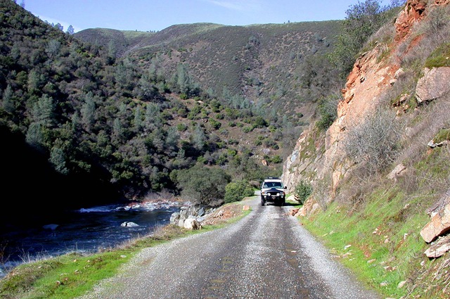
But even in clear weather, caution must be taken concerning mud and rock slides, primarily after a large storm. Even though the small boulders in the picture here are not blocking the roadway, one of these babies slamming into your vehicle could produce some undesirable body damage.

BLM typically closes the road (for undetermined lengths of time) during extremely heavy rains. Now and then the local sheriff might suggest you to leave the area if weather reports predict large storms are to pass through the canyon. If a slide occurs somewhere along the roadway while you�re occupying one of the several camps, prepare to stay for an extended time. You might be stuck there for over two weeks, so be forewarned.
This picture shows where the mountain gave way and took out the road for several days.
But early spring is by far the best time to visit this beautiful section of the Merced River. It�s common to see clear red salamanders meandering around the area; a treat for the younger children to watch.

The elevation is low compared to Yosemite but quite scenic with a few Pines, Manzanita, and Oak trees that dominate the hillsides. Depending on the springtime rains, the local flower bloom, mainly the California poppy occurs around April and into May. Fishing is open year round here (check fish and game rules and regulations) and it can be very good depending on water flows. Trout, certain Salmon species as well as Bass can be caught along the river. A few camping spots offer close access to the river. Most of the camps are walk-in types which are not suited for RV�s and practically none of the RV camps are on the river. This spot is located on a beach and is one of a kind so it�s difficult to find un-occupied. I like the camp pictured below because fishing is only a stones throw away and it�s nice to hear the river flowing at night. Besides, who doesn�t like a beach!

Springtime months are somewhat special to the locals. This is when river rafting is at its peak so kayaks and rafts loaded with people are commonly seen. It�s rated at class IV+ depending on river flows. Several outfitters run this section of the Merced. This web site goes into some detail about the river. Merced-River
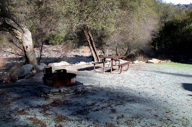
Although fire pits are available in each camp, firewood is difficult to find. There are vaulted toilets at each of the three camps and I have found that both the camps and heads are maintained well during the off peak times of the year. Be advised that there is no drinking water at the camps but there is water available near the ranger�s trailer at the beginning of the road.
I must stress that this can be a place to avoid during late May through early December. The canyon can become a local party spot during weekends and I have found that it becomes congested when the weather begins to warm. Dredging is a big pastime hobby around this section of the river and these devices can be noisy as well. Summer temperatures normally are in the 100+ zone turning the once green grasses to brown by July. Although not commonly seen, this is a rattlesnake zone and must be respected.
Overall, I think Merced river Canyon is a nice spot to visit year round and a great place to camp during winter and spring time when most of the sites are available. The roads slight grade makes for a pleasant walk or bike ride. Nearby Bull Creek Road is a fairly changeling 4×4, ATV, or mountain bike route. The river is generally open to fishing year round when most streams are closed making it possible to throw something on the fry pan or practice catch and release. Finally, because Briceburg is close to Yosemite, these BLM camps make for a good starting point into the national park.
You can read more about the Merced River Canyon in the �Backcountry Adventures??? book (Northern California edition) by Massey and Wilson. This trail is designated as High Sierra #25 plus the book also shows a few other trails located near by. As mentioned, the closest trail (Bull Creek Road) is what the book calls the Burma Grade Trail. Other trails out of the area are Hite Cove and the Ferguson Ridge Trail.
See ya on the trail.
Dave.
Author�s note:
In August of 2008, the Telegraph Fire ran through the Merced River Canyon.
Image from:
GEOMAC Wildland Fire Support

During the 08-09 winter season, heavy rains caused several slides and for safety reasons the BLM closed the roadway down. Unusually late rains kept it closed through much of spring. I have yet to enter the area to see the devastation, but being this zone had not seen a fire for well over 50 years, I�m expecting a big change. As of June 09 the Bull Creek road was still closed. I will update this article when I re-visit the area. Hopefully mud slides will not be as detrimental in 2010 but knowing the area I�m not optimistic at all and believe the possibility of slides will promote road closures.


