
Bull Creek Road (Burma Grade Trail)
Posted on June 17th, 2006 in Uncategorized | 5 Comments »
By Dave Boyer
Another exceptional 4X4 road out of Briceburg and the Merced River Canyon is a backcountry trail that can take you into Yosemite. Called Bull Creek Road or Burma Grade as explained in the Backcountry Adventures book, this trail leads to several other routes above Briceburg including the Old Coulterville Road that connects to the Foresta community located within Yosemite National park.
There are several ways to link up to Bull Creek Rd from Foresta and I prefer to travel towards Briceburg because of the views offered along Bull Creek road itself while descending into the canyon. The winding trail and surrounding hills can give you the impression that you�re in another country, hence its nickname Burma Grade. But taking Bull Creek Road from Briceburg is a fantastic route in itself. This area can be very hot and dry during summer and early fall so the best time to visit is when everything is green. April through May is usually when the flowers are in bloom. Your vehicle should have high clearance and four wheel drive capabilities and if you wish to continue into the park, topographical maps and live GPS programs are good to have on board. There are several forest service roads that can link to each another so you have plenty of roads to explore if you wish. The dirt section of Bull Creek Road can be completed within two hours usually. Now I�ve taken one route from Foresta to Briceburg in a station wagon years ago, but fires have ran through upper section of the countryside over the years which changed many trail not to mention the landscape. It is also possible to run the entire Old Coulterville Road and Burma Grade within a day but that is a several hour journey. The Burma Grade trail can be brutal at times with deep ruts that vary year to year but the trail is generally graded after spring. Another highlight (IMO) is that it features several switchbacks which are mainly located closer to Briceburg. The trail is very narrow in spots and on coming vehicles might pose a problem. Ruts can be two feet or more at times and the clay is very slippery in wet weather. This is one you need to check out before you run it. I�ve pulled my SMB trailer up it a few times with no problems even with heavy ruts in the trail. Remember up-hill vehicles have the right of way.
In April of 2006 I called up my off road buddy Don to join me and re-explore Bull Creek Road. I was ready to put some tests on my new Sportsmobile and this grade was perfect. Both of us hadn�t been on this trail for several years and even though I would have rather ran it from the higher elevation down, I was eager to see it again.
(Please click on any image to enlarge)
We camped at BLM�s Merced River Canyon where we fished, had an evening fire, and sucked down some brews. In the morning coffee was high on the agenda.
 We looked over the maps and talked with the local ranger who was apprehensive about me pulling my trailer up this grade with such a large vehicle. The plan was to make the Bull Creek Road and swing up toward Anderson Flat. Technically, Burma Grade is only part of Bull Creek Road.
The Backcountry Adventures Book is difficult to follow. Bull Creek Road is more of a thoroughfare trail that connects Briceburg with highway 132 which runs through the town of Coulterville. The true scenic beauty along this road is on the lower section where the road follows the bluffs, but to visit the mines along the upper section it seems you have to deviate off Bull Cr Rd. We were pressed for time and being we had only one more day to camp we just stuck to the main trail. Besides, the brush was bad enough along the main route.

We left out along the Merced River to where the trail begins (or ends) and locked up the hubs.
Even though it had rained during the week, the clayish road seemed dry enough.

There are several switchbacks on this route and you quickly climb out of the canyon in a short period of time. After passing through the first set of switchbacks the trail follows a mild section that parallels the canyon for a ways.
.

It curves around several hills which add to the scenic value of this drive.
 Looking down on the Briceburg bridge is a super view and give you some perspective on how far you�ve climbed. An ATV group who came flying around the corner looked surprised at my large van meandering up such a rough road. I asked about the trail ahead and they said it just gets worse at the final set of switchbacks. I sure wasn�t backing down this trail so we pushed on. Several spots were shored up with flat shale rock.

Because of the shoring, it did make me wonder about the weight of my vehicle but the road road has been a stable platform for years.
 Crawling over some ruts I felt a large pop from under the passenger floorboard. It continued whenever I went off camber and it started to bother me. Don got out and walked along as I drove a short distance.
We never did find the cause and figured the spring pack was shifting. At least nothing broke but it was always on the back of my mind.
 I found the most interesting part of the trail was here along these bluffs just before the last switchbacks. It made for a fairly good snapshot.
I would have took more pictures but the popping sound coming from the front suspension was really bugging me.
This was one place that would cost big bucks to get out of.


As we made the final switchback the trail mellowed out and we were moving into a thicker brush and heavier tree cover. Up here we found a bit of mud but nothing worth shifting into four wheel drive.

As the trail climbs, the lower lying brush gives way to a thicker tree line and greener territory. This part of the drive was narrow and scraped the sides of my van but I had to break it in sooner than later.
When your vehicle doesn�t have a scratch on it, crashing through trees is something you try to avoid.
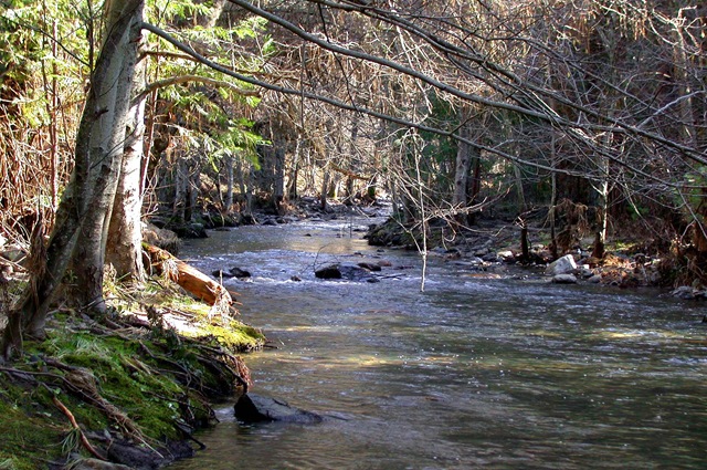
Once we made it to Kinsly Ranger Station the trail becomes a well maintained road designated FR-20. Part of FR-20 is asphalt. Turning left takes you past the ranger station toward highway 132. It also passes a couple nice trails, namely The Old Coulterville Road which is one of the original stagecoach paths into Yosemite. On the other hand, turning right on FR-20 takes you to Anderson Flat area where we had planned to camp for the night. There are a few homes to pass by on the way in but only a couple. What�s really nice is the road follows Bull Creek itself.

This little stream was flowing high at this time of year and there are a few spots to camp along the creek that I prefer over Anderson Flat itself. The forest is thicker with a variety of trees such as pine, oak, and aspen.
Located before Anderson Flat, this area is much more scenic and because of this it�s often occupied. Fortunately it was empty and we grabbed it. Anderson is larger and offers more spots to camp but can be congested at times, especially during hunting season.

The small boon dock spot we chose along the creek is nice but slightly trashy due to its popularity. Too bad people don�t clean up their camps before they leave.

But the areas nice and because everything was cool and damp it made for a nice camp.


That night we fired up the BBQ, skewered some Shrimp, Salami and Shrums. We looked at some of the local varieties, but decided we would rather die from alcohol poisoning.
In the morning we packed up and headed out of the Anderson Flat area. Rather than going back the way we came, we decided to keep heading up FR-20 but found it was washed out and impassable. Oh well, nice trip anyway. If the road was open, it intersects at a spot called 5 corners which is located on the Old Coulterville Road. From that point several paths can be taken to different areas. For us we just called it a day and hit the highway toward the San Joaquin Valley and home. I was very happy with my new vehicles performance and handling on this trip and plan to re-visit this road next year.
Summary:
Although I prefer to take Burma Grade from the higher elevation starting point down to the Merced River Canyon, it�s a great run. The ridge walls and winding road make this route quite spectacular. The trail should be avoided in wet weather and can change dramatically after the rainy season so it should be researched before attempting it. The best time to visit the area is during cooler weather in the springtime when the flowers are in bloom and the grasses are green. The road is fairly short and can be run in about 3 hours. The side roads off the main Bull Creek road can be narrow and overgrown which might scratch your rig. There are several areas to boon dock but the most scenic spots are along the Bull Creek stream.
Trails close by:
Old Coulterville Road.
Trumbull Peak Lookout Road.
Crocker Ridge Route.
Big Creek Basin Route.
Author�s note:
In August of 2008, the Telegraph Fire ran through the Merced River Canyon. It affected certain sections of Bull Creek Road. I have yet to visit the area since the fire devastated this area and have no idea of the scenic or trail damage that may have occurred. For more information see the Merced River Canyon post on this site.


5 Responses
[…] high country. For more details about either of these runs, you�ll find them on this site under Bull Creek Road and The Old Coulterville […]
Hi There.
It was nice reading of your travels.
I live in the little valley by the bridge crossing Bull Creek. I have more history about the area and its former inhabitants if you are interested.
Lynn
Well if you ever see a big white van flag me down. I was sorry to see so much burned during the last fire. At least it didn’t make to your place.
Dave
Hey there, glad I found this post! I was born in Bagby (now Lake Mcclure!) and am planning a “homecoming” (haha) trip this summer and was looking for some nice back roads to explore. This will definitely be one of them as it ends at the spot my folks’ house used to be!
Man this year 2014 you can walk through Bagby.
Dave Boyer