By Dave Boyer
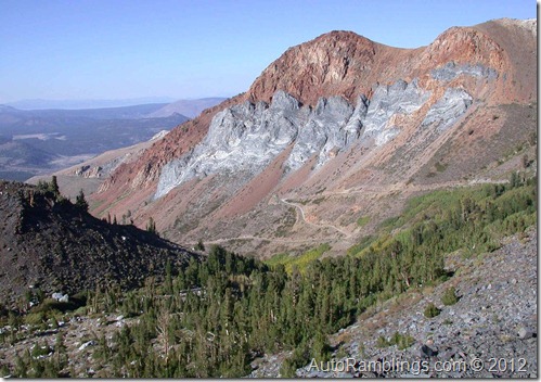
Location:
The east side of the Sierra�s off highway 395 just outside Mammoth Lake California.
Season open:
Between April and November. Weather permitting.
Elevation:
7,000-10,000 feet.
Nearby Facilities & Camping:
Mammoth Resorts and local campgrounds.
The Eastern slope of the Sierra Nevada�s holds a number of trails offering a variety of chances to explore regions that range from desert type zones to high altitude alpine settings. The trail into Laurel Lakes begins in a shrubland type Montane zone that holds sagebrush at the lower end of the trail and then continues through a series of Aspen groves as you climb in altitude. After traveling across a loose open sharp rock portion of the trail, you�ll eventually end in a more Alpine type setting typical to the upper Sierra Nevada�s. The contrast between the zones is quite striking especially during autumn when the trees are producing their abundant fall colors. Due to its location and length, this one way trail can be done easily in a day but because the lower section is very rocky and slow going, adjust your schedule to arrive early as possible. Besides, it�s easy to spend a good portion of the day shooting pictures so expect to add time for that alone. A day of fishing or just a picnic at Laurel Lakes rounds out the day nicely.
Read the rest of this entry »
By Dave Boyer

Click on Smaller images to enlarge
Death Valley is the lowest point below sea level in North America and has been one of California�s national parks that I�ve been interested in seeing for most of my life. In December of 2006 I decided it was time to pay a visit and do some desert exploration. Don, a friend and four wheel drive enthusiast out of Merced wanted to check out the area to see if he could talk his wife into a vacation trip there. Well, it sounded good anyway and he figured it was a good excuse to get away.
Although I prefer pine trees over cactus, my new 4×4 van is well suited for the desert terrain and I�m always willing to explore something new and unique in our great wilderness areas. This was a great trip, especially because it was new to me and neither of us didn�t know what to expect. I had seen some TV documentaries on Death Valley such as Huell Howser�s California�s Gold, but both of us figured actually being there would probably be quite different. Correctamundo! Within a week, we were to find out that Death Valley is truly part of California�s gold.
Read the rest of this entry »

In and around Yosemite
(Part 3)
By Dave Boyer
The Old Coulterville Road. (High Sierra # 28)
October 7-9 2006
In the Fall season of 2006, I made three separate trips to Yosemite to explore areas both inside and outside the Park (see �In and around Yosemite??? part 1 & 2). The final off road run in my three part journey would be The Old Coulterville Road which in part lies within the Yosemite Park boundary. By today�s standards, the road would be considered an improve trail much like many forest service roads. Once again I used the Backcountry Adventures publications as a guide but I�m also familiar with the region. The Northern California edition of the book describes the trail in detail along with other trails that intersect the Coulterville route. This post will key on the individual sections of the trail I took between October and November of 2006 and spring of 2007. Usually I was accompanied by friends during my journeys, but on a few occasions ran the route by myself to complete the trail as described in the book. I have driven parts of the Old Coulterville Road over the years, even as far back as the late 70�s. Of all the times I�ve been on the trail, only once did I complete the entire run as described in Backcountry Adventures and that was in the 70�s with Jerry. I�ll go over the entire route as well as sections of other trails that lead to the town of Coulterville and below to highway 49. Most of the images were taken in the fall season of 2006 but the pictures of the lower foothills during springtime of 2007 will be obvious. I also might throw in some more recent shots of the area taken during various times of the year.
Read the rest of this entry »
In and around Yosemite
(Part 2)
By Dave Boyer
Fresno Dome
September 22-24 2006
") After our trip to the east side of the Sierra�s, (See Tioga to Dunderberg Meadows), we decided to visit an area just outside the lower south east section of Yosemite. Tamarack Flat is only about an hour and a half away from the trail we looked at, so after morning coffee we were off to visit Fresno Dome.
After our trip to the east side of the Sierra�s, (See Tioga to Dunderberg Meadows), we decided to visit an area just outside the lower south east section of Yosemite. Tamarack Flat is only about an hour and a half away from the trail we looked at, so after morning coffee we were off to visit Fresno Dome.
Image from the Fresno Bee.
About the Fresno Dome and the surrounding area:
 Fresno Dome is a unique single granite formation with an elevation of 7,450 feet that towers above a thick forested area located close to upper Sky Ranch road below Yosemite. The dome is situated south east of the National park in the Sierra National Forest. This area is a feasible destination for those who wish to explore four wheel drive routes that are not possible within the national park boundary. Fresno Dome�s dominant feature qualifies it as topographical landmark and was used by John Muir when he explored this region in the 1870�s. A short hike to the top of Fresno Dome offers an exceptional view including a grove of giant Sequoia trees called the Nelder Grove located several miles away.
Read the rest of this entry »
By Dave Boyer.
Tioga Pass to Dunderberg Meadows, September 2006.
In memory of Jerry Richard Repke.
June 14th 1954 � December 3rd 2010.

A Trip into the Sierra�s
(Please click on smaller images to enlarge them)
In September of 2006 I took some time off from work to make several trips into the Sierra Nevada�s with the idea of running a few off road routes in and around Yosemite National Park. The fall season offers mild temps and limited mosquito activity which makes this time of year one of the best times to visit California�s mountainous regions.
Read the rest of this entry »


")


